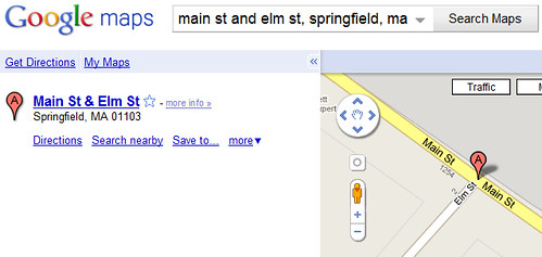
I’m not sure how many people might use this feature in Google Maps, but I suspect that relatively few people are aware that it exists. Google Maps allows one to submit more than just street addresses and city names in order to map location — they also allow you to submit intersections of cross-streets:
To get a map of an intersection of two streets, you merely need to submit the request in this format: “[Street Name A] & [Street Name B], City]. In the above example, I use “main st and elm st, springfield, ma”.
Developers are probably even less aware that this feature is available in Google Maps API as well. Submitting the above location to the API as a geocoding request will return back latitude and longitude coordinates of: 42.101415, -72.587947.
The interpreter in Google Maps doesn’t handle more complex constructions like “End of Main St.” nor “Between Pine St and Church St on Dallas Rd”, and it would ignore more fine-tuning such as “SW Corner of Main St and Elm St”. If you submit only a street name, like “Pecan St, City, State”, without a street number address, it will attempt to pinpoint the centerpoint of that street.
There are some additional types of locations Google Maps can pinpoint as well, such as if you submit raw Geocodes in either minutes/degrees/seconds or in decimal format. And, most are aware that it can pinpoint by city name, and it will also locate by the centroids of ZIP codes.
I’ve seen a lot of cases where database information is very indistinct where addresses are concerned, so hopefully this intersection-mapping detail will be useful to some developers out there.
(If you’re interested in figuring out how to get a quick set of lat/long coordinates in order to add a geocode to a piece of content, see my article on How To Geocode An Address & Optimize Location Pages. You can extract geocoordinates from the Google Maps user interface by mapping a location and then finding the lat/long values in the map link.)
Tags: geocoding, Google Maps, Google Maps API, mapping


 ShareThis
Sorry, it does nog work for example with
Colomalaan and Jubellaan, Mechelen
in Belgium
I came here expressly because I Googled frustration at the system’s inability to recognise intersections. Pretty much every time I google an intersection, it instead takes me to something at/near the intersection using that name. For example, “Yonge and Dundas, Toronto” takes me to “Yonge and Dundas Square,” which is not what I needed directions for.
I can’t get this to work. Maybe it only works in the USA? I’m fro the Netherlands.
Example: kraneweg and Friesestraatweg, groningen, netherlands
It just takes the first streetname, and ignores the second one. I tried with & and ‘en’ instead of ‘and’ as well as different ways of bracketting, with square, curved and curly brackets.
Hello Chris Silver Smith,
Great article just wanted to know is there a way to actually find whether two boundaries ever intersect in google geocoding . Here that will help you understand more what i want
http://stackoverflow.com/questions/11049177/know-whether-two-boundaries-ever-intersect-each-other-in-geokit
could please share the your resource specific link for your in google maps api I myself could not find it though
In Argentina doesnt work
http://maps.googleapis.com/maps/api/geocode/json?address=salta+and+almafuerte,+mar+del+plata&sensor=false
This seems to work whilst online on desktop, IOS Google Maps app and Android app. However, I have my maps downl;oaded offline on Android Google maps (and IOS) and whilst a simple search of an address works offline, the intersection does not and reports data unavailable as offline. Is there a way around this as my Android has to fubction offline?
Thanks